
The coastal hazards physical vulnerability of seven municipalities in Camarines Norte is highlighted in the latest scientific report released by the Marine Geological Survey Division of the Mines and Geosciences Bureau (MGSD-MGB). Covered by the survey are the municipalities of Mercedes, Daet, Talisay, Vinzons, Paracale, Jose Panganiban, and Capalonga. The report contains the most up-to-date information for the province about the threats posed by coastal hazards and the recommendations to mitigate or to minimize their effects on the populace.
The survey team, headed by Dr. Karlo L, Queaño, has applied extensive in-house research and field investigations to establish the coastal vulnerability index (CVI) of communities in Camarines Norte. The report released by the survey team mentioned that a set of parameters was considered in CVI, among which include shoreline changes for the past 10 to14 years; classification of geomorphic units and substrate type; presence/absence of natural buffers (mangroves, seagrass, and/or coral reefs) and hard engineering defenses; and coastline orientation with respect to the dominant wind-driven wave direction. With significant inputs from officials and residents of coastal communities, the application of Analytical Hierarchy Process was also integrated in establishing the coastal hazards physical vulnerability of the province.
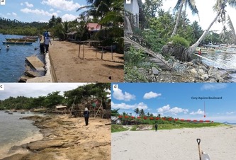
Some photos of areas assessed for coastal hazards vulnerability. These are the eroding coasts in the following areas: a) Brgy. Calabaca, Capalonga; b) Brgy. Pag-asa, Jose Panganiban; c) Brgy. Masalong-salong, Mercedes; and (d) Community in the vicinity of Cory Aquino Boulevard along the coast of Barangay Mampungo, Paracale. The red dash lines indicate the minimum height of storm surge (exceeding that of the boulevard) during the 1995 Typhoon Rosing.
Based on the MGSD-MGB’s report, the province has about 24 coastal communities that are highly to very highly vulnerable to coastal hazards. These communities have experienced about 50 to 100 meters of coastal retreat for the past 14 years. The report also highlights the deterioration of mangrove forests and coral reefs in some areas, resulting to higher vulnerability to storm surge and tsunami, particularly for populated areas along the coast. In view of this, the report suggests the close monitoring and enhancement of these natural barriers, especially in light of the ongoing construction of about 8-km coastal boulevard and seawall between the municipalities of Mercedes and Vinzons that may, in the long-run, have an impact on the sediment budget and growth of mangrove forests and coral reefs in the province.
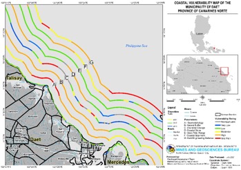
An example of a 1:10,000 scale coastal vulnerability map (Daet Municipality) produced for the province of Camarines Norte.
By: Marine Geological Survey Division