
Knowing that typhoons are a common occurrence battering the country almost every year, expectations that the level of preparation to minimize the impacts of typhoons are high. Unfortunately, the onslaught of Typhoon Odette (internationally called “Typhoon Rai”) that badly hit the Visayan region and eastern Mindanao in December 2021 highlighted the need to go back to the drawing board and to see how resilience in the coastal population of the said regions can be improved. It should be recalled that in the past, typhoons stronger than Odette had already hit and ravaged the Visayas and eastern Mindanao. These include the 1897 strong typhoon event that devastated Samar and Leyte and, in recent history, the 1984 Typhoon Undang that had a strength reaching up to 230 kph. Taking almost the same path as Typhoon Udang, Typhoon Yolanda with gustiness of up to 250 kph hit the region again in 2013. While Typhoon Odette had a much lower maximum sustained wind of 165 kph than that of Typhoon Udang, it caused so much damage to crops and properties amounting to billions of pesos to the point that it is now remembered as the most destructive post-Yolanda typhoon. Unfortunately, Typhoon Odette came at a time when the country and the rest of the world were (and still are) in the process of recovering from the economic slowdown brought about by the Covid-19 pandemic.
With the rather unfavorable climate change scenarios and with more than half of the country’s population now occupying the coast, the ability of local government units (LGUs) and emergency frontliners to respond to natural hazards would undoubtedly be greatly challenged should another strong typhoon hit the country. A grim scenario is predicted when this natural event happens, unless the unexpected consequences of human activities are identified and are acted upon preferably long before another strong typhoon crosses the region.
The one-month long (November 16 – December 13, 2021) coastal hazards assessment and mapping conducted by the Marine Geological Survey Division of the Mines and Geosciences Bureau (MGB) in nine municipalities in southern Bohol, provided an example why the results of the survey, including the advisories issued prior the passage of Typhoon Odette, matter in terms of long-term disaster preparedness plan of southern Bohol and in increasing resilience against coastal floods, including storm surge. Nine (9) coastal municipalities namely, Duero, Jagna, Garcia Hernandez, Dimiao, Valencia, Loay, Lila, Albuquerque, and Baclayon were covered during the assessment. Immediately following the conclusion of the MGB’s survey, the assessment and mapping results as well as advisories were issued to the local government units before the passage of Typhoon Odette. The provincial government of Bohol is thanked for acknowledging the MGB team for the results of the survey and for relaying the results to the concerned offices for their reference and appropriate actions before Typhoon Odette hit the province on December 16, 2021.
To highlight the results of the survey, it was noted that Southern Bohol is characterized by tide-dominated transitional environments marked by the presence of estuaries, tidal creeks and tidal flats that extend for over 50 to 100 meters wide. Such geomorphological features make southern Bohol inherently prone to coastal flooding brought about by tide- and wave- processes, including storm surges. The carbonate shelf that fronts the beach environment of southern Bohol largely attributes to the shallow and gentle morphology of the coast. This, however, is with the exception of that fronting the municipality of Duero where possible offshore geological structure may have resulted in a steeper shelf gradient.
Unfortunately, many mangrove forests in southern Bohol have been partially or completely stripped off through the years of increasing urbanization and changing land use (e.g. tourism development, reclamation). While coral reefs are also present in some areas, their condition has significantly deteriorated through years of misuse and human activities onland (e.g., illegal fishing practices; dumping of waste/wastewater into the coast). Many of these reefs occur as patches within an extensive carbonate shelf that likely was once a haven for dense coral reefs. These include those observed in the vicinity of Pamilacan Island in Baclayon and off the coasts of Lila, Dimiao, Valencia and Garcia Hernandez. Some reefs encountered during the nearshore surveys also showed signs of bleaching.
Among the signs of gross misuse of the coral reefs noted during the field survey is the extraction of coral reefs used for building makeshift coastal defense as noted in a number of areas in southern Bohol. The use of coral reefs as construction materials seems to have had a long history that can be traced back during the Spanish time, when “cut coral stones” were partly used as blocks for building some Catholic churches in Bohol. The use of coral reefs, whether from a living or fossil population, for construction only motivates other people to extract them for a purpose that is detrimental to the coastal ecosystem. The role of coral reefs as a haven to aquatic resources and as natural buffers against wave impacts, including storm surge, is strongly diminished when this happens. In light of this, there is a need to review management plans for the protection and enhancement of coral reefs in the province.
Some areas in southern Bohol have initiated programs for the rehabilitation of mangrove forests and coral reefs for coastal protection against wave action, including storm surges or even tsunamis. However, being at the youthful stage and/or being somewhat patchy (e.g., less than 500 meters wide) and moderately thick, the effectiveness of the mangrove forests as a natural coastal defense against storm generated waves is yet to be fully realized. Moratorium for the cutting of mangroves, mangrove replanting and monitoring of mangrove forest that also involve community participation are among the management strategies to consider. Research indicates that dense mangrove forests should be about 500-m wide to be effective against storm surge.
Anecdotal accounts obtained during the survey consistently point to a landward retreat of the shoreline by as much as 30 meters (or more) in all the coastal areas surveyed starting in the 1990s. Coastal erosion is manifested by exposed tree roots and/or wave escarpment/notches. In addition, anecdotal accounts consistently suggest the presence of a line of trees that used to be located further seaward of the present shoreline. This finding is intriguing considering that Bohol Island is supposed to be within a compressional regime as indicated by: (1) the uplift of recent coral reefs observed in a number of areas along the coast in southern Bohol; and by (2) the reverse fault movement (e.g., North Bohol Fault in the year 2013) that produced strong earthquakes in Bohol. Ideally, the compression should result in tectonic uplift for Bohol, the consequence of which would be a seaward retreat of the shoreline. While this happened to the coastal areas between Maribojoc and Loon in western Bohol following the 2013 earthquake, such event is not reflected by the current situation in southern Bohol in which the current rate of relative sea level rise appears to exceed the rate of uplift attributed to regional compressive stress affecting Bohol Island.
Anthropogenic activities appear to have played a significant role in the diminishing of beach sediments in southern Bohol. These include human activities, which are rather illegal, such as the (1) extraction of beach sands; (2) extraction of coral reefs (also serving as beach sediment sources) which enhances wave impacts alongshore; (3) destruction of mangroves which are vital for trapping sediments and buffering waves; (4) quarrying/extraction of river sediments that should have been supplied to the coast; (5) damming of rivers that result to the trapping of sediments available for downstream transport towards the coast; and (6) erection of hard engineering defenses (e.g. seawall, riprap) that affects the availability of sediments for transport and deposition alongshore. All of these lead to sediment starvation alongshore. Many coastal areas already have exposed bedrock following erosion and/or removal of beach sediments without attendant beach nourishment.
Beach nourishment by rivers is expected to be a slow process in southern Bohol given its rolling/hilly and relatively subdued topography (as compared to mountainous terrains). In such terrains, rivers are generally slow-flowing except under extreme weather conditions. Consequent to this is that it takes longer time for rivers to replenish or nourish the coast with sediments. For this reason, the coastal environment bounded by such onland topography would be very sensitive to any anthropogenic activities that interfere or disturb the natural process of sediment transport and deposition.
In view of the above, local and provincial governments, in coordination with relevant government agencies (e.g., Department of Environment and Natural Resources (DENR), MGB-DENR; EMB-DENR; Philippine National Police; Philippine Coast Guard), should be on guard for such anthropogenic activities, but also taking into consideration the plight of the individuals or parties concerned. In this case, a review of the coastal management strategies by the LGUs becomes particularly crucial.
Hard engineering structures (e.g., seawall) including makeshift coastal defenses (riprap; breakwater) are almost everywhere present along the coast of southern Bohol. Many defenses were put up by property owners, apparently not in close coordination with other property owners, the LGU and/or relevant government agencies (e.g., DENR) and/or without a thorough understanding of the environmental consequences related to the installation of the structures. For instance, when seawalls and riprap are constructed on eroding beaches, the erosion would likely continue so that the beach fronting the seawall can become very narrow or disappear completely. There are numerous areas in southern Bohol exemplifying such scenarios. In addition, while groins and jetties trap sediment on the updrift side resulting in shoreline accretion, there is corresponding shoreline erosion on the downdrift side due to the interruption in longshore transport. Uncoordinated efforts of installing such structures would not only result in the adjoining areas being affected by coastal erosion or accretion following the modification of alongshore sediment transport but also would diminish the aesthetic value of the coast as already demonstrated in many areas in southern Bohol. In the process, this could translate to a loss of opportunity to promote responsible, eco-friendly tourism for the province that could significantly benefit local residents.
While at a first glance, conventional, hard engineering approaches such as seawalls and riprap appear to be the most intuitive defensive tactic against coastal erosion and storm surge, their design should consider not only the hydrodynamics and geomorphologic characteristics of the coast but also the worst case scenario (e.g., maximum height of storm surge based on historical account; rate of relative sea-level rise). In the same way, as the coast is exposed to the denudation processes brought in by wind, waves, and tides, these processes will constantly impact the coastal defense structures. For this reason, provisions for maintenance and repair should be in place to maintain their effectiveness. When all of these are not taken into account, engineering measures only provide a false sense of security against coastal hazards, particularly for those residing behind these structures. As such, and as demonstrated in many parts of southern Bohol, the vulnerability of coastal communities behind these ill-designed and/or poorly maintained structures is only increased by these hard engineering structures. Any hard engineering structure to be put up in southern Bohol should be with the knowledge and in coordination with the local government units and relevant agencies. Barangay-, municipal-, and/or provincial-scale type of structures to be erected or activities (e.g., reclamation; port/pier construction) that could potentially alter the coastal conditions and processes should ideally be with an environmental impact assessment, coupled with an engineering geological and geohazards assessment consistent with the DENR regulations (e.g., DENR Administrative Order No. 2000-28), to strengthen resilience to coastal hazards. Given the current state of the coasts in southern Bohol, further community growth/developments along the active coast is strongly discouraged.
In summary, strategic plans to minimize the effects of coastal hazards should be science-based, requiring coordinated and concerted efforts among the local and provincial government units of southern Bohol and other stakeholders. A much stronger coastal adaptation approach should ideally be coupled with consistent science-based policies applied vertically across different levels of governance and horizontally across neighboring municipalities.
By: Marine Geological Survey Division

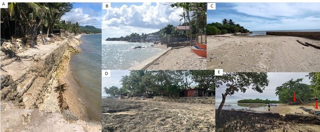
Manifestation of coastal erosion in southern Bohol as exemplified by: (A) partially to completely breachedhard engineering defenses/makeshift coastal defenses and exposed tree roots; (B) landwardshoreline shiftas indicated by drowned/uprooted trees that used to line the shoreline; (C) downdrift sediment starvation due toconstruction of improperly sited coastal defenses; (D) wave-cut/notch at the base of uplifted marine terraces.
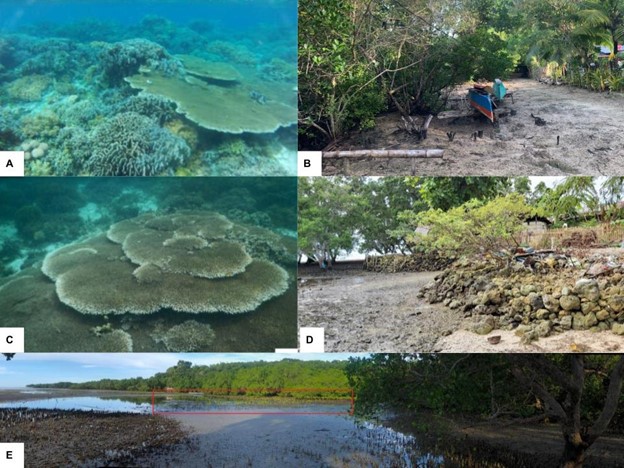
Deteriorating state of natural defenses (i.e., coral reef, mangroves) in southern Bohol as indicated by: (A, C) coral bleaching with links to illegal fishing activities and construction of makeshift coastal protections (D); (B) uprooted mangroves that are planted in areas greatly affected by wind-driven waves. Some municipalities insouthern Bohol have initiated mangrove reforestation; (E.) Being at their youthful stage, however, the mangroves would not be fully effective against storm surge.
Some examples of coastal defenses that are not fully effective against storm surge. A,D-Riprap partly made up of coral reef fragments; B- Improperly engineered coastal defenses (sea walls); C-Discontinuous seawalls that can easily be overtopped by storm surge; E-Makeshift breakwater and riprap already partly destroyed or covered with beach sediments.