With its scenic beauty, rich biodiversity, deep history, cultural relevance, and geological significance – Mount Apo Natural Park (MANP) is regarded to be one of the aspiring United Nations Educational, Scientific and Cultural Organization’s (UNESCO) Global Geoparks in the Philippines. Geoparks are defined as an area with one or more sites of international geological significance that aims to encourage awareness, conservation as well as sustainable use of its geological heritage. If declared a geopark, MANP would officially join more than 170 other global geoparks in more than 40 countries around the world.
Mount Apo is a large dormant and solfataric stratovolcano, with its summit elevation at 2,954 meters above sea level (masl), and considered to be the highest peak in the country. It has been declared a Natural Park by Presidential Proclamation No. 75 in 1936, and later amended by Proclamation No. 35 in 1996. In 1982, Mount Apo was included in the list of Natural Parks and Equivalent Reserves of the United Nations and later acknowledged as an ASEAN Heritage Park. MANP was declared a Protected Area and a component of the National Protected Areas System under Republic Act No. 9237 or “Mt Apo Protected Area Act of 2003.”
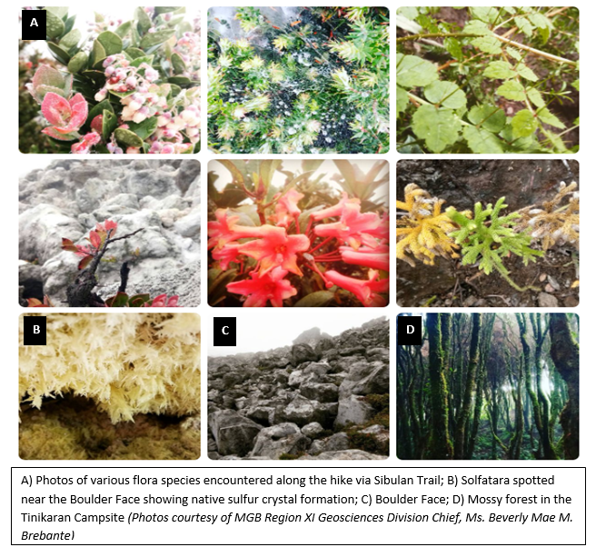
In support of its application to the UNESCO Global Geoparks, geologists from the Mines and Geosciences Bureau (MGB) Central Office (CO) and Regional Office (RO) No. XI joined with personnel from the Department of Environment and Natural Resources (DENR) RO No. XI in conducting the First Rapid Assessment of MANP. The objective of the multi-sectoral assessment was to gather data on flora and fauna, geological features, and delineation survey and mapping from Sibulan Trail in Sta. Cruz, Davao del Sur traversing to New Israel Trail and exiting to Energy Development Corporation (EDC) Executive Trail in Kidapawan City, North Cotabato.
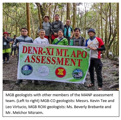
The four (4)-day rapid assessment was conducted from March 18 to 22, 2022 led by the DENR RO XI Regional Executive Director (RED) Bagani Fidel A. Evasco. who acted as the overall coordinator and head of the management team. The team was also joined by Dr. Alberto N. Bandiola, PENRO Davao del Sur as deputy coordinator, together with the MANP Protected Area Superintendent (PASu), Dr. Joel S. Pardillo as the chief of operations.
The MGB team was composed of four (4) geologists, headed by Ms. Beverly Mae M. Brebante, Chief of Geosciences Division of MGB RO-XI, Mr. Melchor G. Mizraim, Jr., Geologist II from MGB RO-IX, and two (2) representatives from the MGB CO, namely, Mr. Leopoldo T. Virtucio, Senior Science Research Specialist, and Mr. Kevin Bien D. Tee, Senior Geologist.
Future rapid assessments will be undertaken in the other trails surrounding Mt. Apo to get a clearer picture of the interesting sites around the area.
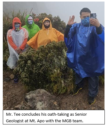
One of the highlights of the MGB team’s ascent to Mt. Apo was Mr. Tee’s oathtaking as a Senior Geologist near the summit of Mt. Apo (approx. 2,900 masl) on the morning of March 21, 2022. The MGB team witnessed the event in the midst of rain and strong winds in the area. The oathtaking was the first of its kind in the history of the DENR. Even MANP PASu Dr. Pardillo congratulated Mr. Tee on the accomplishment which may be a sign of greater things to come.
By: The Lands Geological Survey Division