
Tourism, fishing, and aquaculture are industries with major economic influences on coastal ecosystems (Population Reference Bureau, 2003). These industries prompt urgency for coastal developers and policymakers in establishing coastal developments to meet public demand and sustain economic growth. Such coastal development includes the construction of coastal boulevards for access, reclamation of the foreshore area for landmass extension, and installation of hard engineering coastal structures to defend the coasts from potential coastal hazards (e.g., storm surge, coastal erosion, coastal inundation). While such fortifications allow for the protection of the fronting coastal zones against the effects of climate change-related hazards, science-based information should be sought and considered in effectively providing long-term solutions to chronic coastal problems.
As one of the parameters in quantifying the physical vulnerability of coastal zones against the effects of coastal hazards, the suitability and sustainability of hard engineering defenses sited in Sorsogon City facing Sorsogon Bay were assessed by the Marine Geological Survey Division of the Mines and Geoscience Bureau - Central Office from September 16 to October 14, 2022. The validation is part of the Coastal Hazards (Physical) Vulnerability Assessment and Mapping of southern Bicol region and is intended to guide provincial and local governments on their coastal management planning and adaptive strategies for mitigating climate change-driven coastal hazards.
To note, studies proved that the country is experiencing thrice the global sea level rise rate. This quantity is expected to be exacerbated in selected areas where specific coastal landforms promote coastal flood funneling and entrapment (i.e., bays with restricted mouths; subdued tidal flats; numerous estuaries and tidal creeks). In the country, it is in the intuition of the public to install coastal defenses to help minimize, if not – totally mitigate, the effects of the rising sea level. Such man-made, hard-engineered coastal defenses include groins, tetrapods, seawalls, and breakwaters, among others; let alone soft coastal defenses individually constructed by coastal populace (i.e., sandbags and/or ripraps constructed by beach resort owners). To focus, the southern portion of Sorsogon City fronts the tide-dominated Sorsogon Bay. The bay is also surrounded by the municipal borders of Castilla, Casiguran, Juban, and Magallanes. At the bay’s southwesterly mouth, deposits of the Bulusan Volcano, the Pocdol Volcanic Range, and the Manito Volcanics contribute to the restricted, sheltered morphology of the bay (Figure 1). Similarly, active tectonics along the Ticao Pass may have provided some structural controls on the presently restricted morphology of the bay’s mouth. These promote the development of tidal creeks, estuaries, and low-lying coastal areas surrounding the bay which placed selected municipalities surrounding it to higher susceptibility to coastal flooding. In the event of storm surges, storm wave direction can coincide with the opening of these channels and serve as pathways to easily flood the inland areas. Moreover, anecdotal accounts suggest further inland incursion of coastal floods occur during the coincidence of storm surges and high tide conditions.
Furthermore, the situation in Sorsogon City facing Sorsogon Bay (Figure 2A) is particularly alarming for several reasons: First, coastal boulevard and seawall construction is coupled with reclamation of tidal flats behind the seawalls (Figure 2B). While this strategy could effectively minimize floods resulting from tidal incursion and storm surge, it could cause flooding in built-up areas behind the reclaimed areas particularly during extreme weather conditions. Flooding in these areas is likely to be magnified because the seawall and the associated reclamation are already impeding the natural efficient flow of rivers and surface runoff from the upland areas toward the coast. This was actually validated by concerned Local Government Units (LGU) during our virtual Information, Education, and Communication (IEC) campaign held on 24 October 2022 (Figure 3). While box culverts (Figure 2C) have been installed in some sections within the seawall to allow tidal creeks to empty their load, these culverts also serve as pathways for tidal incursion and storm surge to penetrate inland. Second, reclamation activities and seawalls already in place are sited in front of mangrove forests. In effect, these human-induced modifications of the coast would effectively result in the demise of the mangrove forests behind the seawall and reclamation areas as optimal conditions for their growth have been altered (Figure 2D). Third, the reclamation affects a wide span of tidal flats that are also host to important natural ecosystems other than the mangroves.
In other places, such as in the northern coast of Sorsogon, seawalls are damaged and are reported to have been overtopped by past and/or recent storm surges (Figure 2E). Unless relative sea-level rise is taken into account in the engineering design and provisions for maintenance and repair are in place, hard engineering defenses such as seawalls are likely to fail in the long run. It should also be emphasized that, although the construction of seawall allows for the protection of properties/infrastructures by controlling the beach erosion, this kind of fortification causes wave refraction and intensification of lateral longshore currents that cause the removal of beach sands. This is already somehow manifested in seawall-protected coastal areas facing Albay Gulf and Sorsogon Bay.
The provincial government and the concerned LGUs may want to review their coastal defense strategy which considers integrating ecosystems-based coastal defense with hard engineering measures. This hybrid approach could offer greater protection against storm surges which through the years, are expected to worsen due to stronger typhoons. With climate change, hard engineering defenses as a stand-alone solution to mitigate coastal hazards are likely to fail. In addition, these structures diminish the aesthetic value of the coast if they intend to utilize the area for recreational and business purposes. Finally, hard engineering defenses should be put up only when needed, knowing that they can cause coastal erosion in other areas (Figure 4) and bring irreparable damage to the natural ecosystems whose interaction with the marine environment would be restricted by these defenses. This is particularly true in rural and/or coastal communities of relatively low populations. In these areas, adaptation approaches that include relocation to more elevated regions far from the reach of storm surge may be the most cost-effective, long-term strategy to mitigate coastal hazards. To this end, given what we have witnessed so far, hard engineering defenses may be an unsustainable approach if science-based information is not considered as presented herein.
By: Marine Geological Survey Division
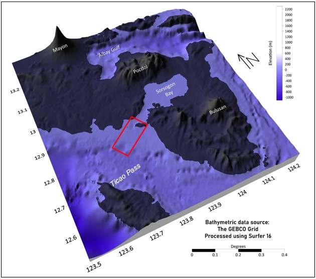
Figure 1. Topographic and bathymetric map of southern Bicol region. Boxed in red is the restricted mouth of the Sorsogon Bay. Processed and generated using Surfer 16. Open data source: The General Bathymetric Chart of the Oceans (GEBCO).
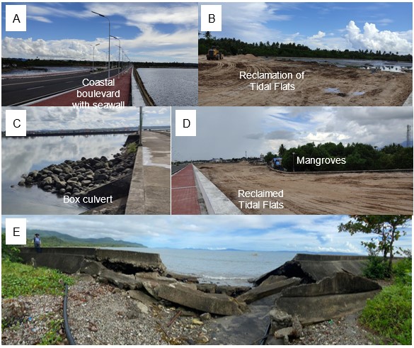
Figure 2. Field validation in Sorsogon City facing Sorsogon Bay. A coastal boulevard with seawall is sited along the coast of Barangay Balogo, southern Sorsogon City (A). In some parts of Barangay Balogo, reclamation of tidal flats behind a coastal boulevard with a seawall is ongoing (B). Some of the seawalls are installed with box culverts to allow drainage of surface and upland runoff (C). Mangrove forests on the tidal flat were cut off of their natural ecosystems as a result of the reclamation (D). In Barangay Poblacion, northern Sorsogon City, a seawall was breached and reportedly overtopped by previous storm surges (E).
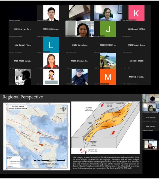
Figure 3. A virtual Information, Education and Communication (IEC) campaign was held on October 24, 2022 to present the results of the Coastal Hazards (Physical) Vulnerability Assessment and Mapping of Sorsogon Province. The IEC was spearheaded by the MGSD-MGB and was attended by Sorsogon LGUs, PENRO Sorsogon, PENRO-PGO Sorsogon, and MGB Region V. Pull apart basin model of Wu et al., 2008.
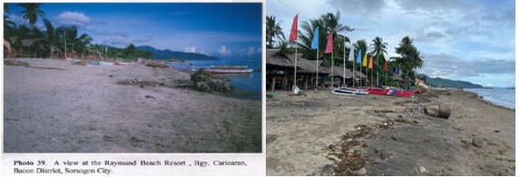
Figure 4. Coastal erosion in Sorsogon City as documented by the narrowing of the beach through comparison of 2006 MGB Report on Coastal Geohazards (left) and 2022 MGB Report on Coastal Hazards (Physical) Vulnerability Assessment and Mapping (right).