
It has been reported as the rate of sea level rise dramatically increased in the last century, majority of the low-lying areas in the Philippines is projected to be partially or completely inundated. The Mines and Geosciences Bureau (MGB) recognizes the need to conduct assessment of the vulnerability of the coastal areas to this climate-change driven hazard as it poses a threat to the coastal communities and the marine environment. In this regard, a team from the Marine Geological Survey Division (MGSD) conducted coastal hazards (physical) vulnerability assessment and mapping in Masbate City and in the municipalities of Mandaon, Milagros, Aroroy, Balud, San Fernando and Monreal in Masbate Province.
Utilizing observations gathered during the field survey and published geologic data, the MGSD-MGB noted the presence of active offshore faults in the immediate vicinity of Masbate Island. Alongside this, the MGSD-MGB advised the LGU and the provincial government of Masbate to review their long-term development plans, considering that reclamation and attendant increase in urbanization/developments within the reclaimed area are only bringing the population nearer to the faults. It is worth noting that several reclamation works in Masbate City and adjoining areas were reportedly implemented in the absence of an in-depth geologic/scientific study and in the lack of the necessary permit. The conduct of scientific study and corresponding thorough review before reclamation projects are implemented in compliance with existing laws and DENR Administrative Orders, are particularly very crucial for Masbate City and for other areas on the eastern coast of Masbate island (facing Masbate Pass) as these areas are within or in the vicinity of the Philippine Fault Zone. This makes the area highly susceptible to earthquakes-related hazard, particularly ground shaking, liquefaction, and lateral spreading. While the trace of the fault in the southern portion of Masbate island is already mapped, the onland extension of the fault in the north still remains to be scientifically investigated. With this, ground rupture is a potential hazard that should also be considered in the eastern coast of Masbate island. In addition, the MGSD-MGB reported that many of these reclaimed areas lie on the reef flat zone, former mangrove swamp/tidal flat, and the foreshore, disrupting not only the sediment transport dynamics but also contributing to further destruction and decline of the natural habitats (i.e., coral reefs; and mangrove forests). In view of this, the MGSD-MGB calls for strict enforcement of the law and action from the local and provincial government to halt and to prohibit further expansion of reclamation activities in the province.
The MGSD-MGB further identified the uncoordinated installation of makeshift coastal protection and structures as one of the major culprits in enhancing coastal erosion. Illegal beach sand extraction which was observed in a number of coastal areas in Masbate was noted as also contributory to enhanced coastal erosion affecting the province. On the other hand, rapid urbanization/development, illegal hauling of corals and dynamite fishing, reclamation and installation of hard structures led to the decline of natural buffers such as mangrove forests and coral reefs which once predominantly characterized the coast zone of the province. Clearly, the dwindling mangrove forests and coral reefs has only increased the coastal communities’ exposure to coastal flooding and erosion, especially with the advent of climate change-driven sea-level rise.
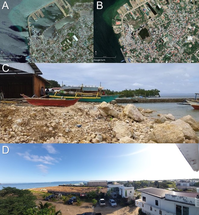
Comparison of the 2010 (A) and 2023 (B) satellite imageries of a coast in Masbate City showing rapid reclamation;
Coastal reclamation alongshore Masbate Island (C, D)
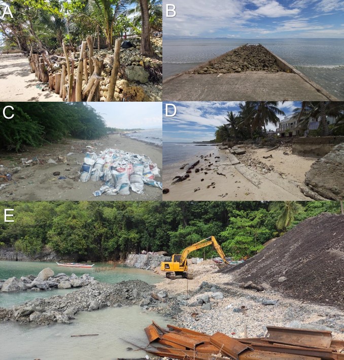
Extracted corals used as makeshift coastal protection (A) and construction material (B); Beach sand extraction
(C); Damaged makeshift seawall (D); and ongoing construction of a seawall at the toe of a steeply sloping terrain.
By: Marine Geological Survey Division