
Everything on earth undergoes perpetual modification and for that reason, every entity is transitory in nature. Some will exist in just a split second, while others will take hundreds, if not millions of years, to decipher the changes. While a number of these alterations are not easily conspicuous to the naked eye, others are highly evident and merit imperative detection.
Wondering where on earth is the place where change is always inevitable, because of its dynamism? The answer is of course, our shorelines.
If you spend a minute in the beach, barefoot, you will experience sand filling the spaces between your toes alongside the rhythm of the waves - that’s a micro-scale phenomenon. Stay in the same location for a week, and you will notice the sand berm, rise or diminish its height. Reside there for a year and you will notice sandbars curved like a bow along the mouth of the river.
One may have a hard time discerning the transformation of stump, seastack and sea arch per se from its original form which is a headland, because these succeeding events generally happen in a grand-scale.
All these coastal modifications can be attributed to coastal processes known as weathering, erosion/accretion and/or shift, which are the principal driving forces of shoreline changes.
 The isolated rock stock outcropping along beach of Bgy. Omawas, Maydolong, Samar was originally part of the promontory (black dashed lines suggest the original outline of the promontory). Due to actions of wave, erosion and weathering, it became a sea cave and then a sea ark (as shown by the arrow) and eventually a sea stack.
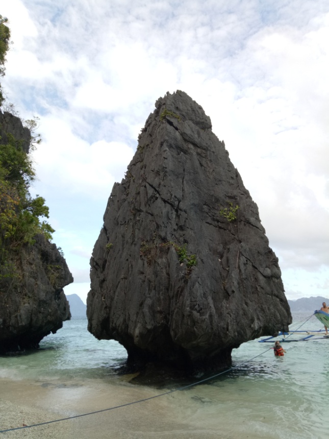
Above photo shows a seastack photographed at El Nido, Palawan. A seastack is a coastal erosional landform formed by wave action and is typically exemplified by steep and vertical column.
The fact that the Philippines is an archipelago, touted as having one the longest coastlines in the world and with a tectonic setting considered as one among the most active in the world, our country is therefore susceptible to ceaseless coastal processes.
So, what causes these changes and what are their implications to our country’s coastal peripheries?
The ways by which erosion and accretion transform our coastlines are primarily due to many factors most particularly the prevailing waves, current and tides including the geology, geomorphology, climate/weather phenomena and human incursion.
Waves, currents and tides can influence the coastal areas in many ways and are the primary causes of coastal abrasion/erosion and to some extent, of coastal accretion. Stronger wave energy equates to higher rate of erosion and/or accretion.
The geology of a coastline is a vital factor to shoreline change including the coast’s rock assemblage and its tectonic imprints.
The country’s coastal fringes are underlain by intertonguing rock facies mostly composed of limestone, sand and alluvium. The succession of bays and headlands/promontories in most of our coastal boundaries best explained these phenomena. Bays are usually made up of weathered and softer rocks which are prone to erosion while headlands are made of tougher materials and last to be eroded.
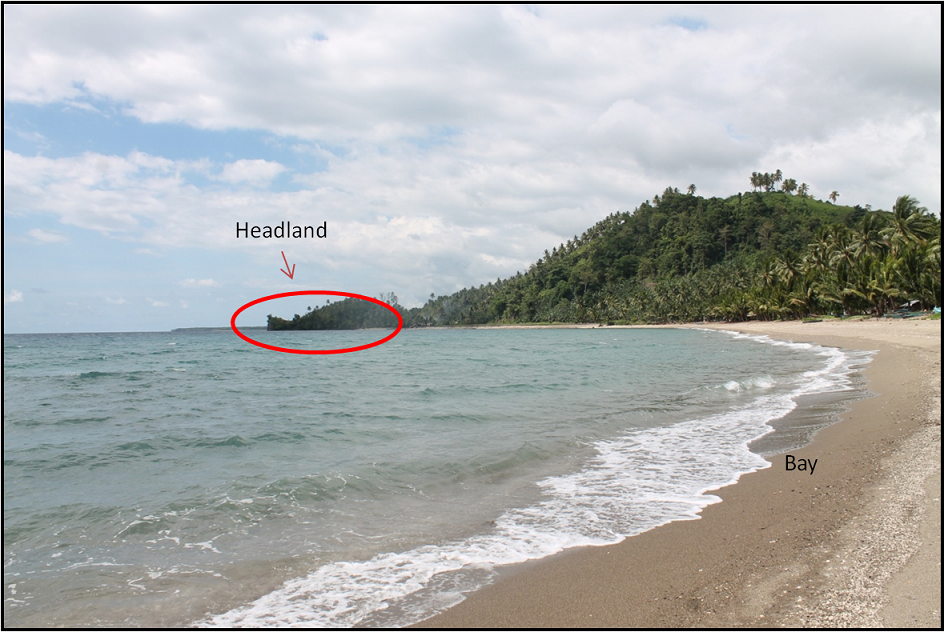 Headland (encircled) made up of harder rocks, hence the last to erode while the bay is of composed of softer rocks and the first to erode.
High energy waves could crack up rocks and eventually dislodge blocks at the foot of a nearby cliff, creating a rocky coast. This process creates dramatic landscapes along the coast such as caves, arches, stacks, tide pools, etc. and is called coastal abrasion or erosion.
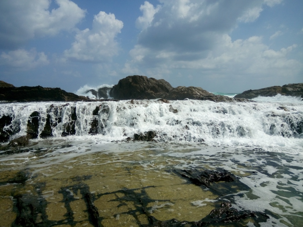 Photo above and the video below show strong ocean waves crashing against rocks forming spectacular rock formations, tide pools and terraces.
Generally, rocky coasts imply high rate of erosion/abrasion. But the presence of coral/reefal flats along the nearshore somehow dissipates the energy of the waves before reaching the shores.

Fringing reef are exposed during low tide at Brgy. Dalumoines, Calubian, Leyte.
The tectonic configuration of the Philippine archipelago also bears a significant impact on shoreline change. The country is situated along the Circum Pacific Rim of Fire where the process of plate convergence is actively ongoing. As a consequence, the eastern part of the archipelago from Luzon through the Central Philippines down to Mindanao is regarded as the mobile belt, while Palawan and Sulu Seas are considered stable regions. Coastal changes brought about by tectonic movement are likely to happen along the shores of the mobile belt region. One recent event was where the shoreline suddenly shifted seaward, as an aftermath of the 2013 Bohol earthquake.
The magnitude of coastal changes relative to its geology, is easier to quantify but its frequency is quite harder to decode due to the non- predictability of tectonic events.
The coastal shape, topography and near-shore bathymetry also dictates the rate of shoreline changes.
Beach dimension controls shoreline pattern. Wave energy dissipates in wider shore due to loss of friction, and this equates to less erosion. This is best exemplified in Boracay in Aklan and Puerto Galera in Mindoro.
On the contrary, a narrower beach will mean that the breaking point of the waves is proximal to the coastline; therefore less energy is lost due to friction before they break and most likely suggests faster progression of coastal erosion.
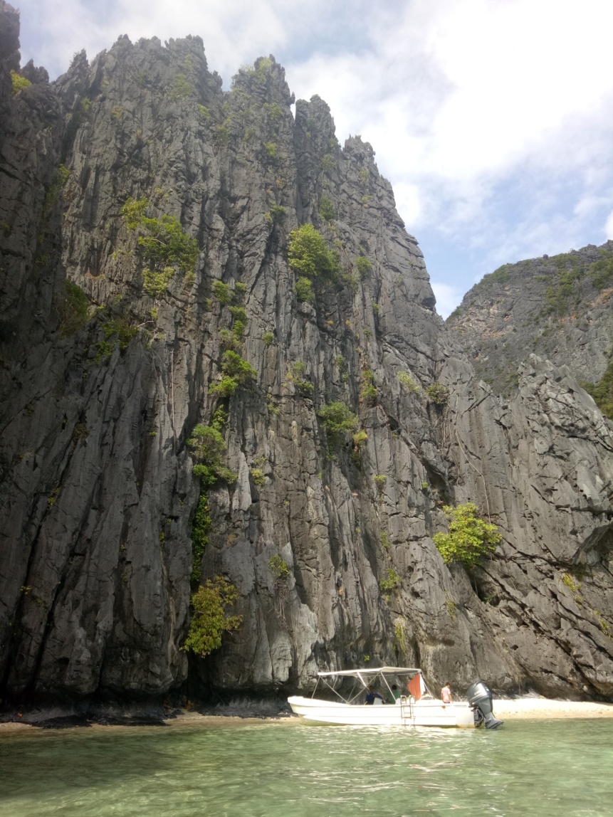
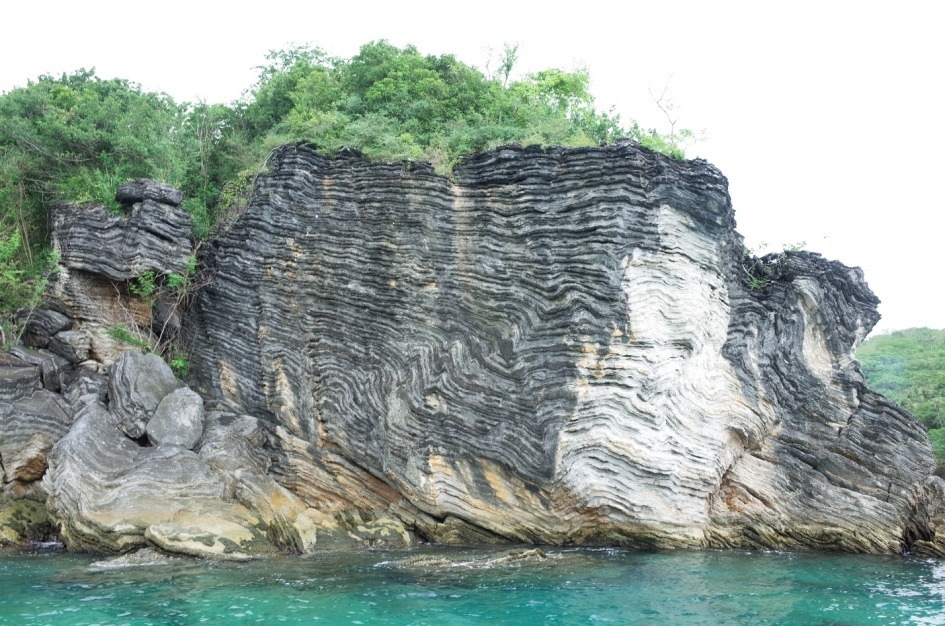
If the beach gradient is steep, this will encourage steeper and higher-energy waves. This is because beach materials leave less energy for backwash and are therefore more susceptible to erosion. The magnificent limestone cliffs in Coron and El Nido, Palawan are experiencing this event.
 Pinnacle karst exposed along the coast of El Nido with notches at the base as a result of wave and water action.
 Another prominent limestone block with contorted bedding that served as wave dissipater in Caramoan, Camarines Sur.
Waves during extreme weather conditions are more dangerous in areas with a gently-sloping seafloor since there is no barrier for the waves to stop the surge from going further inland. This is almost true during the onslaught of Yolanda Typhoon in 2015 which almost phased out the eastern coast of Leyte.
The magnitude and frequency of coastal change relative to geomorphology may be conducted by knowing the sedimentology and morphology of the coast.
Climate is as well one important factor that dictates coastal modification. Monsoons and cold fronts may increase precipitations which can propagate high and stronger waves. Moreover, the relative sea level rise causes shoreline retreat and may aggravate coastal erosion.
The country is subject to frequent onslaught of high waves as it is surrounded by major ocean bodies, including the South China Sea on the west, the Philippine Sea on the east and Celebes Sea on the southwest.
Therefore, most of the country’s coastal rims are susceptible to erosion, especially those facing the Philippine Sea where most of the destructive cyclones occur.
The frequency and magnitude of coastal alterations due to climatic condition are the easiest to study since they are on a seasonal basis.
Activities induced by anthropogenic factor along the coast such as construction of houses, dams, erection of seawalls, groins, and piers/ports, and removal of sediment or building/mining purposes influence coastal alterations may have immediate, as well as long term repercussions. All of these coastal alterations alter natural processes since some will interrupt littoral drift and impoundment of sand at the expense of the beach downdrift of the structures. Perhaps, one clear example of increased erosion resulting from human alterations can be demonstrated in densely developed areas and other urbanized areas.
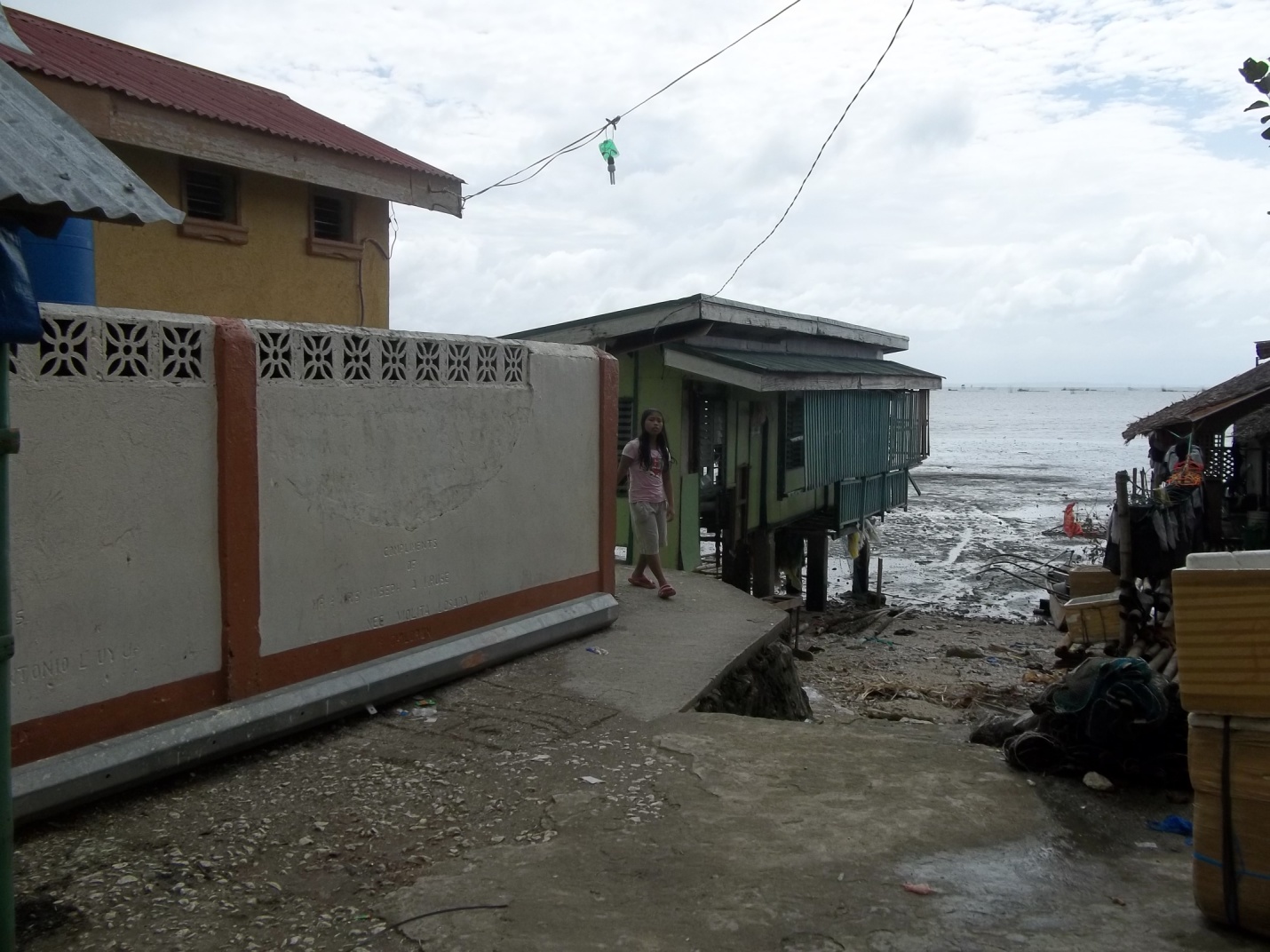 Houses constructed along the coastal proximities of Tabong municipality in Samar Province are threatened to be washed out due to coastal erosion.
As a synopsis, the coast is a sensitive environment where incessant change is expected as this is the way the shore seeks its equilibrium. Therefore, it is fundamental to understand the compelling forces acting on our shorelines considering that about 60 %( Phil. Coastal Marine Resources: An Introduction-World Bank) of the country’s total population is mushrooming in our coastal rims. After all, these expanses remain very unstable and at the forefront of all known hazards despite the spectacular sceneries it offers to mankind.
By: Marine Geological Survey Division