
The Mines and Geosciences Bureau (MGB) of the Department of Environment and Natural Resources has expanded its Geohazard Assessment and Mapping Program to include subsidence susceptibility assessment due to sinkhole collapse in areas of the country that are characterized by karst topography.
Karst topography is a landscape characterized by features indicating dissolution of underlying soluble rocks by surface or groundwater. These soluble rocks are mostly carbonate rocks consisting of limestone and dolomite.
In the Philippines, carbonate rocks occupy a large portion of the natural landscape, comprising about 1,171 municipalities. The subsidence hazard susceptibility assessment will cover all areas of the country underlain by limestone and other soluble rocks.
On the other hand, sinkholes are ground depressions or openings formed when the underlying soluble rocks are dissolved, resulting in voids underground which can weaken the support for the overlying surface.
Subsidence due to sinkhole collapse is one of the most dangerous geohazard because of its extreme unpredictability. This information can be used by local government planners and individual landowners to make decisions on where to build dwellings and other structures.
In its subsidence susceptibility assessment, the MGB utilizes the most recent remote sensing data consisting of IFSAR-Digital Elevation Model (DEM) and IFSAR-Orthorectified Radar Image (ORI) for year 2013 acquired from the National Mapping and Resource Information Authority.
The Geographic Information System (GIS) technology is also used to identify limestone terrain, describe and analyze karst features, detect geological structures important to karst development, and obtain the morphometric attributes of sinkholes. This is augmented by field data gathered through geological and geomorphological assessment and mapping at scale of 1:10,000.
The Program also employs a Ground Penetrating Radar (GPR) survey component. GPR is an electromagnetic technique useful for ground subsidence and sinkhole detection. Through GPR survey, layering in soils and rocks can be mapped, and underground objects and voids can be detected. All the 15 regional offices of the MGB have been equipped with GPR units.
The MGB’s GPR surveys are focused on areas experiencing rapid growth and development and/or envisioned for development. Specific areas where GPR survey is conducted are evacuation centers, settlement sites, and economic zones in karst areas that are prone to land subsidence due to sinkhole collapse.
Eighteen municipalities in Bohol, and one in Negros Occidental have already been assessed by the MGB in 2014. For 2015, the MGB aims to finish the subsidence susceptibility assessment of 15 municipalities in the country.
After each subsidence susceptibility assessment, the LGUs concerned are furnished with the subsidence susceptibility maps. Threat advisories are also issued with the corresponding recommendations to ensure awareness and preparedness on the part of the communities.
Information, education and communication campaigns on subsidence hazards are also conducted among local chief executives and barangay chairpersons prior to the issuance of threat advisories.
The results of this assessment have been extensively used by the provincial and municipal local government units (LGUs) for their rehabilitation efforts following the 7.2 Mw Bohol earthquake on October 15, 2013.
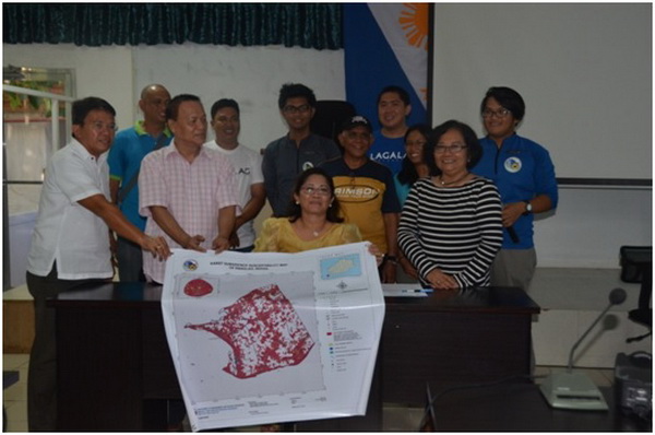
The MGB Sinkhole Assessment Team with local government officials of Panglao, Bohol during the turn-over of the subsidence hazard map and threat advisories in May 2015.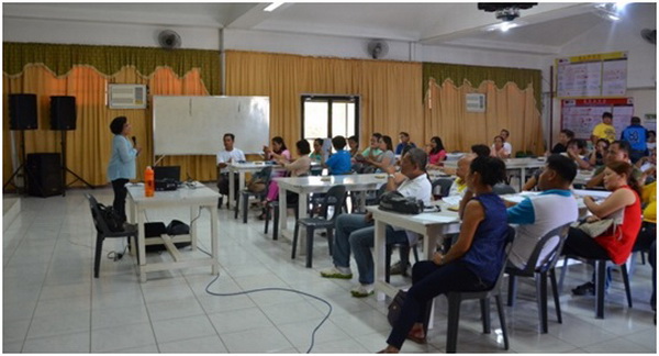
Geologist Liza Manzano, MGB Sinkhole Assessment Team member, giving a lecture on subsidence hazard among LGU officials, teachers and barangay chairpersons in the Municipality of Baclayon, Bohol in May 2015.
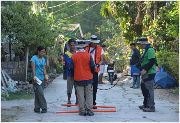
The MGB Sinkhole Assessment Team performing a ground penetrating radar survey on a subsiding road surface in Bohol.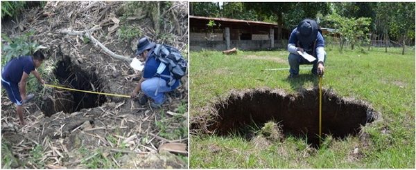
The MGB Team doing morphometric measurements of sinkholes in Bohol.
By: Lands Geological Survey Division