
The Mines and Geosciences Bureau (MGB) will produce groundwater availability maps on a scale of 1:250,000 covering the whole country. This map and the accompanying report can be used as guide by Local Government Units (LGUs) at the provincial level, for the development and conservation of groundwater resources.
This activity is part of the Groundwater Resource and Vulnerability Assessment Project under the Geological Assessment Program that is currently being implemented by the MGB. The Project aims to determine the availability and quality of groundwater in the various rock units of geologic formations and assess groundwater vulnerability of aquifers in the country. Systematic and standardized procedures for mapping, sampling and data collection, supported by the use of specialized equipment such as georesistivity equipment and in-situ water quality equipment, are used by MGB in the Project.
The production of the 1:250,000 scale groundwater availability maps constitutes the initial 3-year phase of the Project covering all the provinces of the country. For 2016, 18 provinces are targeted. The next phase of the Project will produce more detailed groundwater availability and vulnerability maps at 1:50,000 scale which are usable for LGUs at the municipal level.
By: Lands Geological Survey Division
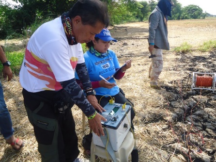
MGB personnel conducting georesistivity survey in Brgy. Lelemaan, Manaoag, Pangasinan.
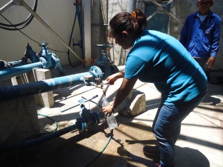
Geologist conducting water sampling for water quality determination in Brgy. Poblacion, San Jacinto, Pangasinan.