The Lands Geological Survey Division (LGSD) of the Mines and Geosciences Bureau - Central Office (MGB-CO), together with the Geosciences Divisions of all the Regional Offices (ROs), recently organized the 2019 Annual Geoscience Workshop. This year’s workshop was successfully hosted by MGB RO No. III at Xenia Hotel, Clark Freeport Zone, Pampanga, from January 18 to 22, 2019. The Annual Geoscience Workshop is the culmination of the past year’s geoscientific field activities where the Bureau’s geologists converge and discuss the geologic data and information which may be utilized for the current year’s activities, such as mineral exploration, resource assessment, land use planning, disaster preparedness and risk reduction and mitigation.
Engr. Paquito T. Moreno, Jr., CESO III, Regional Executive Director of DENR Region III, graced the opening ceremony and welcomed the participants. He encouraged them to contribute to the discourse on the relevant issues to be discussed during the workshop. Mr. Antonio N. Apostol, Jr., LGSD Officer-in-Charge, opened the Day 1 activities by stressing that the annual gathering aims to encourage scientific discussion among colleagues and keep them abreast with updates on current geo-scientific concepts and technologies.
Ms. Liza Socorro J. Manzano, Supervising Science Research Specialist, MGB-CO, gave an overview of the history and concept of geoparks. Ms. Manzano presented some steps that will help the Philippines’ efforts toward declaration of its first geopark. These are: educating the local communities regarding the geosites in their vicinity, engaging them via the bottoms-up approach, and promoting responsible tourism.
Ms. Jocelyn C. Villanueva, Senior Science Research Specialist and Officer-In-Charge (OIC) of the Geological Laboratory Services Section, presented the functions and accomplishments of her section. She also revealed a template for a standardized sample index form to be used by the Central and regional offices when submitting samples for analysis.
Day 2 began with a plenary session on the LGSD geodatabase. Ms. Carleen Joy T. Gatdula, Senior Science Research Specialist of the Lands Geological Information Management Section, MGB-CO, together with technical assistants from her section, demonstrated the various new and updated features of the geodatabase.
Five (5) parallel sessions were conducted after the plenary session, namely, 1) Geologic Quadrangle Mapping; 2) Vulnerability and Risk Assessment (VRA) and Information, Education and Communication Campaign on VRA; 3) Subsidence Hazard Assessment and Pre-Disaster Risk Assessment; 4) Groundwater Resource and Vulnerability Assessment (GRVA); and 5) Mineral Reservation Program.
The presentations and discussions of the parallel sessions extended up to Day 3. These are some highlights of the parallel sessions. The mapping team representatives from the Central and regional offices presented the ongoing, updated and/or final geologic maps of the quadrangles they have surveyed for 2018. Likewise, the representatives of the survey teams that undertook groundwater vulnerability assessment and mineral resource assessment reported their findings in the GRVA and Mineral Reservation sessions, respectively. Mr. Carl Reiner T. Padua, MGB-CO Geologist, discussed the official MGB information and communication protocol for disasters made for the MGB Operations Center (OpCen) and MGB Quick Response Team (QRT). Ms. Manzano emphasized the need to immediately update the geohazard maps whenever disastrous events occur.
After the parallel sessions, the groups were herded back into the plenary room and the important matters discussed during each session were synthesized. Dr. Maybellyn A. Zepeda, Supervising Geologist and Chief of the General Geology Section of LGSD, provided a status report of the National Geologic Quadrangle Mapping Program which commenced in 2016 up to 2020. Dr. Zepeda presented recommendations to address the concerns of the Central and regional offices in the implementation of the 2019 and 2020 targets. Messrs. Aniano D. Torres and Salvio B. Laserna, Chiefs of the Hydrogeology and Environmental Geology Section and the Geohazard and Engineering Geology Section, respectively, discussed the 2018 accomplishments and 2019 targets of their sections.
On behalf of the Acting Assistant Director, Ms. Socorro Oquendo, Officer-in-Charge of the Planning, Policy and International Affairs Division, MGB-CO, formally closed the workshop proper citing the significance of the gathering to share information and knowledge among the MGB’s geologists.
On Day 4, to cap the workshop with an inspiring geological experience, the host region brought the participants on a three-hour trek to Pinatubo Crater.
This is the 5th geoscience workshop organized by LGSD. The other four (4) workshops were held in Panglao Island, Bohol; Tanza, Cavite; Lipa/Malvar, Batangas; and Malilipot, Albay.
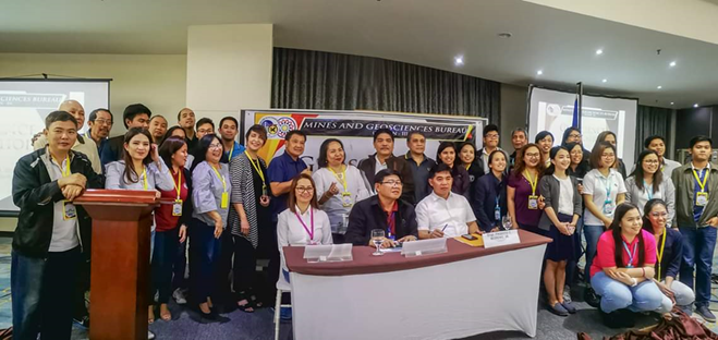
The attendees from the MGB-CO together with (R-L) Engr. Paquito Moreno (Regional Executive Director, DENR RO III), Mr. Noel B. Lacadin (Chief, Geosciences Division, MGB RO III), and Ms. Joselyn C. Carbonell (Chief, Finance and Administrative Division, MGB RO III). (Photo credits to Mr. Jerali Rodrigo, Senior Geologist, MGB RO VII)
By: Lands Geological Survey Division